 ComingUp
FishingNavigationCore
Competition-tested fishing GPS source code for straight-line return navigation

Is this your project? Ask us to take it down
Gallery
About
FishingNavigationCore – Professional Fishing Navigation System | Complete Android Source Code
A GPS navigation application developed for competitive fishing and tested in real-world conditions on the water, offering new possibilities for boat-assisted rig placement and fishing.
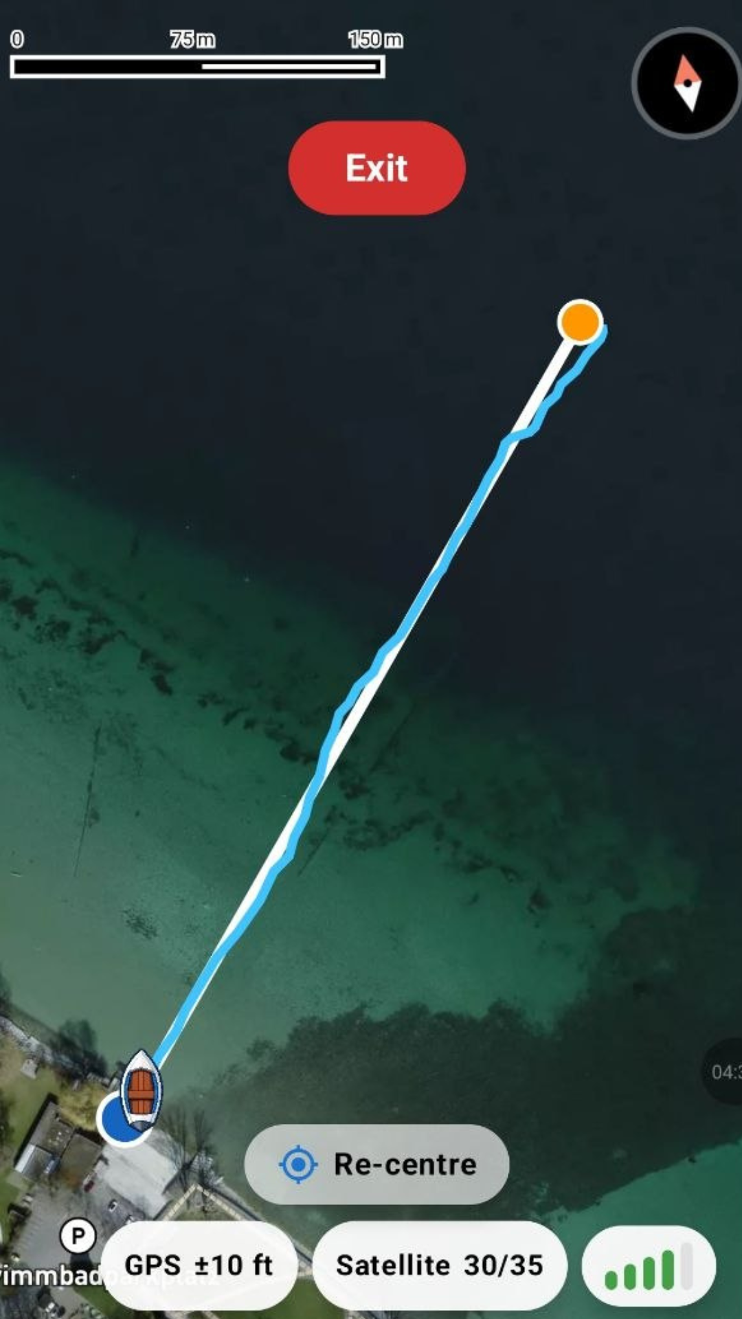
FishingNavigationCore is an Android-based GPS navigation system developed primarily to meet the needs of competitive anglers and those who use boats to position their fishing rigs. Its purpose is to help anglers accurately locate their baited spots, position their rigs in the correct direction, and return to the shore or fishing platform along the straightest possible route.
Why Does This Provide a Real Advantage in Competitive Fishing?
In competitive fishing, every minute and every metre can make a difference.
When placing rigs at long distances, one of the biggest challenges is not necessarily finding the right baited spot, but navigating back to shore. In windy conditions, waves, flowing water, or at night, it can be extremely difficult to maintain a perfectly straight return course using visual references alone.
If the boat deviates from the ideal route, a significant bow or belly can develop in the fishing line. When the line is subsequently tightened, the rig may be pulled away from the baited spot — the very location the angler carefully selected and prepared.
One of FishingNavigationCore's most important features is designed to address exactly this problem.
The application's GPS navigation continuously displays the ideal return direction, the deviation from the straight-line route, and the necessary course corrections.
This allows the angler to navigate not simply towards the shore, but specifically along the straight-line route between the baited spot and the original departure point.
This can help anglers:
- Reduce the formation of line bow and minimise the risk of the rig moving out of position.
- Keep the hook and bait correctly positioned within the baited area.
- Save time during long-distance rig placement and return navigation.
- Fish more efficiently with fewer subsequent line adjustments.
- Maintain the intended GPS course even in darkness, wind, and challenging visibility conditions.
Many anglers are familiar with this type of precise, destination-based GPS navigation primarily from expensive, specialised fishfinder and marine navigation systems. FishingNavigationCore makes this navigation capability available on an Android smartphone, without requiring a separate dedicated navigation device.
Developed and Tested in Collaboration with a Competitive Angler
The system was not developed solely on the basis of theoretical concepts.
It was developed in collaboration with an experienced competitive angler, incorporating real-world fishing experience, challenges encountered during competitions, and practical ideas for making boat-assisted rig placement more efficient.
The application has also been tested in real-world conditions on the water, including on Lake Constance (Bodensee), over navigation distances of approximately 1,600 metres.
The central goal of the development process was to create a practical navigation system that genuinely assists anglers during fishing, rather than simply displaying GPS points on a map.
Key Features
GPS Navigation and Automatic Return Guidance
The system supports both direct navigation to a selected destination and linked navigation. Linked navigation guides the angler from the departure point to the baited spot and then back to the original departure point.
Saving Fishing Locations and Baited Spots
Users can save their fishing platform, shoreline departure points, proven fishing locations, and baited positions. Previously recorded locations can then be found again on future fishing trips.
Underwater Features and Sonar Survey Area Management
Users can record underwater obstacles, drop-offs, holes, plateaus, areas of aquatic vegetation, and other important underwater features. Water-depth information can also be saved for surveyed areas.
Sharing Fishing Locations
GPS coordinates and associated location data for saved fishing spots can be shared with other anglers. This is particularly useful for fishing partners, teams, and competitive anglers fishing together.
Detailed Navigation Statistics
The system records a wide range of information, including distances travelled, navigation times, speed, deviations from the intended route, and estimated fishing-line bow.
During and after navigation, numerous detailed measurements are available, including:
- Current, average, and maximum travelling speed.
- Distance travelled and remaining distance to the destination.
- Total navigation time and time spent moving.
- Time spent at the baited spot.
- Deviations from the ideal straight-line route.
- Estimated fishing-line bow during navigation.
- Additional statistics related to navigation performance.
Built-In Speedometer and Two Measurement Systems
The application includes a GPS-based speedometer.
Users can choose between two measurement systems:
- Metric: metres, kilometres, km/h.
- Imperial: feet, miles, mph.
This makes the system convenient to use for both European and American anglers.
Improved GPS Data Accuracy
When saving a location, the application uses multiple GPS samples and filters out larger positioning deviations. Actual accuracy naturally depends on the smartphone's GPS receiver and environmental conditions.
Not Just for Competitive Anglers
Although FishingNavigationCore was developed primarily for competitive fishing and boat-assisted carp fishing, it can be used for any fishing method that involves travelling by boat to a precisely defined location or requires previously saved positions to be located again.
It can provide valuable assistance to recreational and competitive anglers, carp anglers, boat-based bottom anglers, and users of other water-based fishing techniques.
What Does the Buyer Receive?
The product being offered is the complete, functional Android Studio / Kotlin source code, which can be used to create a fishing navigation application under the buyer's own brand.
The project is fully customisable and can be developed further. Buyers can add new features, services, or custom solutions based on their own business objectives.
This offers app developers, software companies, and fishing-related businesses the opportunity to build upon an existing, functional navigation system that has already been tested in real-world conditions, rather than having to develop the entire solution from scratch.
More Than 25,000 Lines of Android Source Code
FishingNavigationCore is not a basic application template or a sample project consisting of just a few screens.
The system contains more than 25,000 lines of Kotlin source code, covering navigation algorithms, map rendering, location-data management, statistical calculations, the user interface, and business-related functionality.
The project was developed in Android Studio using Kotlin and Jetpack Compose.
21 Language Versions – Prepared for International Markets
The application already includes 21 language versions, with translations developed to provide a natural, native-language experience for local users.
The available language versions are:
- English
- German
- French
- Spanish
- Italian
- Hungarian
- Portuguese (European)
- Portuguese (Brazilian)
- Dutch
- Polish
- Czech
- Slovak
- Slovenian
- Croatian
- Serbian
- Romanian
- Bulgarian
- Albanian
- Russian
- Turkish
- Hindi
This allows buyers to think beyond a single country and enter international markets with an already prepared, multilingual user interface.
The entire application can be customised with different brand names, visual designs, and business models.
Integrated Advertising System – Google AdMob
The application already includes Google AdMob integration, with the necessary advertising placements and management functionality.
The system supports:
- App Open Ads displayed when the application is launched or opened.
- Full-screen advertisements (Interstitial Ads).
- Small and large banner advertisements.
- Ad-free access for premium users.
Buyers need to create their own Google AdMob account and configure the appropriate advertising identifiers within the project.
The code and display structure required for the advertising system are already in place, so buyers do not need to develop the entire ad-management system from scratch.
Integrated Firebase Analytics and Crashlytics
The project includes Google Firebase Analytics event tracking and Crashlytics integration.
Tracking events are prepared for various user activities, including:
- Opening screens and menu sections.
- Starting navigation.
- Saving fishing locations, baited spots, and other GPS points.
- Using language and measurement-unit settings.
- Accessing premium features.
- Other important in-app actions.
Buyers can create their own Firebase project and configure the application to connect to it.
This makes the system suitable for analysing user activity, understanding usage patterns, and supporting future development decisions.
Mapbox Mapping System
FishingNavigationCore uses the Mapbox Maps SDK mapping system.
Mapbox provides the technology required to display maps, while GPS positioning data is supplied by the device's own location services.
Buyers only need to create their own Mapbox account and configure the corresponding access token to use the mapping service through their own account.
Create a Mapbox account:
Mapbox also offers a free usage allowance, which may allow the mapping service to operate without additional charges at lower levels of user traffic.
Any costs beyond the free allowance depend on Mapbox's current pricing terms and usage volume.
The mapping integration is already included in the source code, so buyers do not need to develop their own mapping engine.
Integrated Premium System and In-App Purchases
The application also includes premium purchase functionality built around the Google Play Billing system.
The project includes:
- Management of free and premium access levels.
- Restrictions and unlock mechanisms associated with premium features.
- Premium purchase screens.
- Handling of one-time premium purchases.
- Verification and restoration of previous purchases.
- Ad-free access for premium users.
Buyers can create their own premium product in their Google Play Console account and configure the corresponding product identifier within the project.
The system is already prepared for a premium monetisation model. Additional subscription options or other monetisation structures can be implemented through further custom development.
White-Label, Customisable, and Expandable System
The project includes predefined configuration options that allow buyers to set up:
- Their own application name and brand information.
- Their own Android application identifier.
- Their own Mapbox access credentials.
- Their own AdMob identifiers.
- Their own Firebase project.
- Their own Google Play premium product identifier.
- Their own support and privacy information.
The system can be further developed and used commercially under the buyer's own brand, in accordance with the rights defined in the purchase agreement.
The buyer receives the complete source code. Customising the application for their own brand, configuring third-party service accounts, verifying the production release, and carrying out any additional development are the buyer's responsibility.
A functional, professionally developed, multilingual Android fishing navigation system, tested in real-world conditions, that can save its next owner significant development time and effort.
Comments (0)
No comments yet. Be the first to comment!
Related Products
iZoneMedia360 .com – Trusted Hub for Startup & Tech Innovation Trends
An SEO-ready content blog focused on digital media, tech, and business topics wi
Kanso Rental Property Management System
High-end rental property management tool with little competition + large market
Aakhya.AI - Intelligent Cloud Cost Optimization Platform
Intelligent Cloud Cost Optimization Platform

Workalizer
Google Workspace AI-driven insights to improve productivity and performance

e-mail.dev
Turnkey email validator Micro-SaaS on a premium .dev domain.
The Real World of Autism
Globally raising Autism Awareness and Monetizing all parties